Day 23: Coupeville
Miles Driven: 30 (Brooke drove)
Highways: 525, 20
Weather: Mid 50s, partly cloudy, a few sprinkles, but otherwise dry
Elevation: 75 feet
Brooke and I visited Coupeville, WA today, a town laid out in the 1850s by Captain Thomas Coupe. The town is within the Ebey's Landing National Historic Reserve, which preserves and protects the natural historic farming lands, and is included in the National Parks program. Captain George Vancouver and Colonel Isaac Ebey were among the early explorers in the late 1790s, and the area later included settlers who traveled west along the Oregon Trail.
This is a charming town on Puget Sound with restaurants, quaint shops, a launching pier, and wonderfully preserved Victorian Homes.
 |
| Old time "shotgun houses" or painted ladies |
 |
| A well-preserved Victorian |
The town celebrates Halloween in a big way, with activities throughout October. A couple of the decocrations made me grin. Here they are!
 |
| The Headless Horseman |
 |
| A local farmer |
We had lunch at the Front Street Grill - a very yummy hamburger. Ashley was a delightful server who is having a mermaid tattoo inked onto the entire length of her right arm - the outline is complete awaiting the coloring. When I mentioned she needed a merman on her other arm, she said her merman was at home. Cute. Here's Ashley . . .
 |
| Ashley, server extraordinaire, with the mermaid arm |
Some pics from the historic pier in Coupeville.


 |
| Looking out at the Sound from the restaurant |
 |
| Looking back at the restaurant from the pier - the brown building on the far right side |
Today was a wonderful way to end my visit with my friend Brooke. We had a grand time of it the past few days. Two final pics from the day's meanderings.
 |
| Gorgeous blue berry bush |
 |
| Yours truly with a fellow reader |
This is the last post on Page C. Tomorrow I will begin posting on Page D for the last couple of days of my journey as I turn my trusty RAV4 homeward bound. One more ferry ride to the mainland and then look for me on I-5.
**************************************
Day 22: Greenbank ~ Anacortes ~ LaConner
Miles Driven: 90 (Brooke drove)
Highways: 525, 20
Weather: Rainy, Windy, Chilly 50s, some sun!
Elevation: 56 feet
Elevation: 56 feet
Such a relief to have Brooke drive! I rarely get to enjoy the scenery along the road unless I stop, as I'm usually the driver. We buckled up, put the seat warmers on high, and headed north on an entertaining adventure.
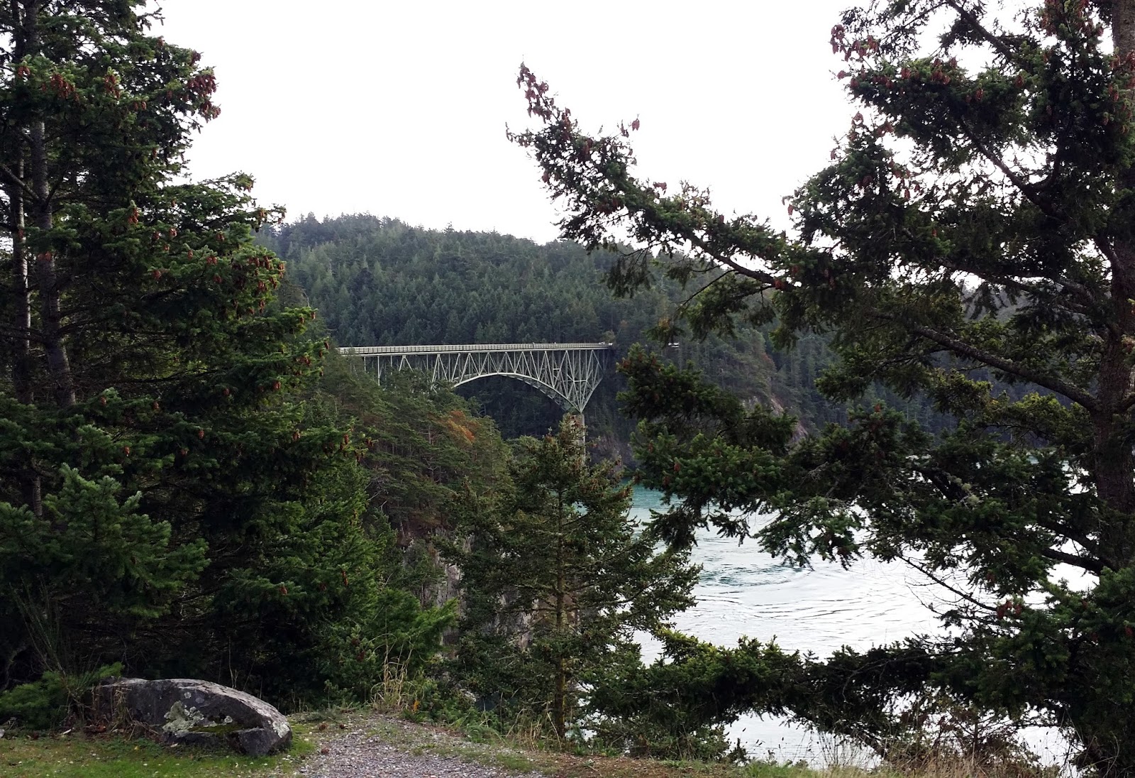
In order to reach our final destination, we needed to cross the bridge over Deception Pass onto Fidalgo Island; across the island we crossed another bridge to jump onto the mainland and head south to LaConner.
Here are some pics of Deception Pass and the Wallace Bridge.


One of my most favorite towns in Washington State is La Conner, named after Louisa Conner by her husband, John, who in 1879 established a trading post in the area. Today the town hosts the Tidal Commission, a world-renowned yacht builder, artistic shops, restaurants, and Gaches Mansion, a restored 3-story Victorian which is now a quilt museum. There are only 12 quilt museums in the US, and this one is quite elegant, with three stories of continually changing quilt exhibits.
Gaches Mansion was built in 1891, is 4700 sq. ft. with 11-foot ceilings. The Gaches family lived here until 1905, when they sold the mansion for $3000 to Dr. Howe, who used it as a hospital. Over the years other families owned and lived here. In 1974, to prevent the mansion from being destroyed, concerned citizens obtained National landmark status for the structure and purchased it for $16,000. In 1997 the Gaches Mansion became home to the La Conner Quilt Museum. The structure has survived a devastating fire and had several restorations.
 |
| Gaches Mansion |
Three exhibits were on display this month: Ekphrastic: Quilts and Poetry, Fibre Arts Network; The Nature of the Place; and Best of the Festival (winners of the recent quilt show). A few of my favorites are shown below.
 |
| Paper Birch and Alder by Ree Nancarrow |
 |
| Braided River Rocks by Ree Nancarrow |
 |
| Willow Thicket by Ree Nancarrow |
 |
| Musicman of Jaipur by Linda Anderson - 1st Place Pictorial Art Quilt Award |
The town of La Conner is a pretty village on Salish Sea near Skagit Bay. Some pics below were taken from the hill above in the Butterfly Garden.
 |
| Waterfront shops |
 |
| Rainbow Bridge |
We had lunch on the wharf at La Conner Seafood and Prime Rib House. A couple of views from the deck are below.


*****************************************************8
Day 21: Port Ludlow ~ Port Townsend ~ Whidbey Island
Miles Driven: 33
Highways: 19, 20, Ferry, 525
Weather: Rainy, Windy, Chilly 50s, some sun!
Elevation: 10 feet
Yes! I arose early, packed my bags, and headed out again for the infamous Port Townsend to Coupeville Ferry. I arrived in time to catch the 9:30 run and made it to Whidbey Island around 10:10 AM. A bumpy ride over rough water, truly cold wind, and grey skies - which seem to be a theme around here during this time of year.
I made it to my friend, Brooke Wills's home in Greenbank for a 4-day visit. She has beautifully landscaped grounds in her front yard and a great view of the sound from her back deck as pictured below.
 |
| The front yard with evidence of Autumn leaves; boathouse in the back |
 |
| Left view from back deck |
 |
| Right view from the deck, the greyish land in the distance is Port Townsend |
Brooke and I met on two cruises related to Authors at Sea as well as a Romance Writers of America convention. Brooke moved to Whidbey almost 2 years ago and lives in a lovely secluded area on the opposite side of Puget Sound from my friends in Port Ludlow.
We headed to lunch in her quaint village at this place:
 |
| It's always nice to know who your dining companions are . . . |
Below is a map showing some of the spots I've been in and will visit over the next couple of days. This map is the northwest corner of Washington state, British Columbia, Canada is due north.

On the lower left find Port Ludlow. Port Townsend is due north. The ferry transports cars, trucks, and people to Coupeville, northeast of PT. Brooke lives in Greenbank, (not visible on map) which is about 15 miles south of Coupeville. Tomorrow, Brooke and I are heading to LaConner and the Gaches Mansion Quilt Museum via Fidalgo Island and Anacortes, further northeast on the map. Bridges connect Fidalgo to both Whidbey and the mainland.
To give you a better perspective of my location, Victoria, BC is located northwest of Port Townsend, and Seattle is due south of Everett on I-5. I-5 is one of the longest north-south highways in America, from the top of Washington to San Diego, CA. I live off I-5, 350 miles due south of Seattle. We are all connected in some way.
*************************************************************
Day 20: Port Ludlow ~ Port Townsend ~ Port Ludlow
Miles Driven: 38
Highways: 19 & 20
Weather: 40s to 50s, high wind warning, storm warning, rain, wind
The forecast was looking pretty grim for the weekend and I decided to make an early dash for the ferry in Port Townsend that would take me over to Whidbey Island. Due to the storm warnings and the high tide issues, quite of few of the ferry trips have been canceled.
Checking the Washington State Ferries website, I saw that the 2:00 PM ferry had car vacancies and I booked passage, packed up my stuff, and headed to Port Townsend - a 30-minute drive. I encountered increasingly bad weather as I headed north to PT, tree branches fallen across the roadways, high winds, and grey clouds. I made it to the ferry and got in my boarding lane. However, after a 90-minute wait with no ferry in site, they canceled the ferries for the rest of the day.
I headed back to Port Ludlow to my very kind friends to stay with them yet another night. We dined on Patagonia Shrimp, potatoes, salad, and wine with chocolate truffles for dessert. The wine was welcome and warming as the storm raged on through the night.
*********************************************
Day 19: Port Ludlow, WA
Weather: Mid 50s, high wind warning, probability of rain 85%
So far the promised storm has not arrived. However, it is chilly, grey, and windy; so much so that we experienced a power outage this morning. This is doubly a problem for my friends due to the fact that they are on a septic with an electric water pump, meaning no water either. But the power is back on, the water is running, and the manly workers with their iron machines have arrived. Work on the front lawn area has commenced with all the noise and commotion that such activities provide. Below are some pictures of the view in both directions ~ the Puget Sound and the front lawn.
 |
| Right side view |
 |
| Left side view |
 |
| The manly men breaking up and moving concrete (the guy in the foreground is not farting!) |
 |
| My friends and a neighbor overseeing the manly men |
 |
| A Yang Ming freighter passes by |
While everyone is outside in this miserable weather, I'm warm and cozy inside, with the spectacular view of the sound and my knitting. I'm working on a Mystery-Knit-Along that might be a shawl ~ not sure. Clues for additional sections come in weekly. I've learned a number of new knit stitches and to add shiny beads to the work.
 |
| A Mystery-Knit-Along in process |
****************************************
Day 18: Ritzville, WA ~ Gig Harbor, WA ~ Port Ludlow, WA
Miles Driven: 290 Miles, 5.5 Hours (including delay due to bridge being raised)
Highways 90, 18, 5, 16, 3, 104
Weather: 31 to 57 degrees, sunny, scattered clouds
Elevation: 3000 feet down to 62 feet
Today was primarily a travel day from eastern Washington to western Washington for a visit with my friends Debbie and Kim Cote in Port Ludlow, a wee town that lies against the Puget Sound. I met Debbie several years ago in a Photoshop class at a local college and we became fast friends. They retired and moved to Sequim and later to their newest home on the Sound. Currently there is a lot of upheaval in the front yard as dozers and other machinery of destruction are repairing and changing a variety of wrong landscape decisions by the prior owners. Here's Kim and Debbie!

On the way to Port Ludlow I stopped in Gig Harbor for some libation. I ate at my favorite restaurant, enjoying fresh caught Halibut Fish and Chips. Terribly Good.

Outside the Tides Tavern, a favorite with the locals, I walked along the boat ramp and took some random shots on this lovely sunny day.
 |
| Boats and WOW, it's Mt. Ranier in the distance |
 |
| Docked boats at Gig Harbor |
 |
| How the other half lives . . . |
A major storm warning is out for the area and may bring big winds and even bigger rain tomorrow. I'm planning on being stuck inside with my knitting and audio books and visiting with my friends. Fresh cracked Dungeness Crab is on the menu. Decidedly wonderful.
***************************************
Day 17: Kalispell, MT~Coeur d'Alene, ID~Spokane, WA~Ritzville, WA
Miles Driven: 290 miles, 5 hours
Highways: 93, 200, 135, 90
Weather: 27 to 53 degrees, snow in the morning again, partly Cloudy in ID, Sunny in WA
Elevation: 4700 feet at Lookout Point, MT, ended the day at 1800 feet
For the second day in a row I woke up with my car buried in snow. The sun peeked out around 9:00 AM and began the meltdown process. Due to the unpredictability of the weather, I decided it was most reasonable to get out of Montana ~ as quickly as possible. The friendly hotelier checked out the road condiions and directed me on some alternate byways that shaved about an hour off the driving time, while providing some spectacular views of Flathead Lake and Lookout Point. Unfortunately, no good photo ops presented themselves due to weather, traffic, and available turnouts. Flathead Lake is a true marvel.
In the final two hours of my drive I managed to be in 3 states and got one hour younger as I passed back into Pacific Standard Time Zone. Sadly, I didn't look any younger.
I drove until I was tired and ended up in this wide spot in the road, a small town clinging to the edges of Interstate 90. Since I wasn't able to get to Whitefish or Glacier NP, I thought I'd pop in a few photos from my 2004 visit to Glacier when the weather was fine.


*******************************************
Day 16: Kalispell, MT
Miles Driven: In town, 10 miles
Weather @ 2:30 PM: 37 degrees, snow melting, car cleared for takeoff
Elevation: ~3000 feet
Weather @ 7:00 AM: 33 degrees, snowing and windy
Weather @ 2:30 PM: 37 degrees, snow melting, car cleared for takeoff
Elevation: ~3000 feet
It finally felt safe to exit the motel and do a little sightseeing, bundled up in my warm jacket and wearing leggings underneath my slacks. I wandered over to Old Town Kalispell to visit some of the local artisan shops. Unfortunately, along with the bad weather, it was also Columbus Day causing some of the shops to close for the day. But I did get to visit quite a few places of interest, including a terrific yarn shop and a wonderful fabric store ~ two of my most favorite things.
 |
| Camas Creek Cottage Yarn Shop |
 |
| Lots of yarn! |
 |
| More yarn! |
 |
| My wonderful find of some Australian variegated yarn for a lace shawl |
 |
| Glacier Quilts storefront |
 |
| WOW, look at all that fabric . . . and those quilts! |
 |
| Oh My! I think I see more fabric. |
 |
| I couldn't help myself . . . found some wonderful batiks |
Due to the weather impacting the timing of this trip, and my cousin Karin's illness, I've decided to reroute my trip, skipping Leavenworth this time around. Instead, I'm spending an extra day in Montana to visit Whitefish and Glacier NP, originally planned for today. Then I'll probably head to Coeur d'Alene, ID on my way to western Washington. Stay tuned.
Weather @ 7:00 AM: 33 degrees, snowing and windy
Not sure if I'll be doing anything today. Here is what my car (on right) looks like out my motel room window this morning. And it's still snowing! I may have to stay in all day and knit! More updates later. Brrrr!

****************************************************************
Day 15: Malta, MT to Kalispell, MT
Miles Driven: 340
Weather: Ranged between 36 and 57 degrees, cloudy, then heavy rain
Highways: 2, 93
Elevation: From 2300 feet to 5200 feet
Today I departed from Malta and my good friend, Elizabeth. The drive to Kalispell took about 6 hours due to my pesky "low tire inflation" warning light coming on repeatedly. I finally realized that the sensor in the spare tire which is in an exterior carrier was causing the sensor light to come on.
With that dilemma solved, I was free to enjoy the majestic Rocky Mountains, as Highway 2 skirted the southern edge of Glacier National Park. Unfortunately, a heavy downpour for the last 100 miles obscured some of the majesty of these great behemoths, and stopping for photo ops at lookout points wasn't a reasonable activity. After spending 2 weeks mostly looking at high desert type landscape, the pleasure of observing mountains resplendent with Evergreen trees juxtaposed against the variant colors of deciduous trees ~ elms I think ~ was particularly welcome.
Some interesting facts about U.S. Route 2: it is almost 2600 miles long and travels across the northern US. In Montana, it touches 3 Indian Reservations, a National Park, and crosses the Continental Divide. It's Western terminus is Everett, WA, near Seattle.
 |
| I took this picture a few years ago during my last trip through Glacier NP . . . it's still cool. |
East of the Continental Divide is the town of Cut Bank, which claims to be the coldest spot in the nation (lower 48) with recorded temperatures of -44 degrees F, before windchill factor is added in. Cut Bank is so named due to a cut bank or gorge which is also a scenic hazard to navigation.
 |
| The gorge in Cut Bank |
 |
| Yep, it must be true . . . the penguin says it is so |
US Route 2 also closely parallels the northern route of the Lewis and Clark Expedition. As of today I have managed to travel all of that route through Montana, Idaho, Washington, and Oregon which includes a visit to their Winter Camp in Astoria, OR. Earlier during this trip I traveled L & C's southern route. Not bad.
 |
| The Lewis and Clark Expedition routes |
It was a long day of driving (6 hours), thus all I've managed to do is plan activities for tomorrow around town, at Whitefish, and in Glacier and have a great dinner at Famous Dave's BBQ restaurant. Yum! Memphis ribs, catfish fingers, beans, corn on the cob, and onion strings. So very good.

Tomorrow I have plans to visit Glacier NP and head to Whitefish, a town originally developed when the Great Northern Railroad was built there in 1904.